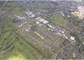
Originally, Kincora
Park and Carew Park were to be retained and refurbished. They
are now earmarked for demolition.
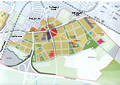
Extract from the
'Master' Plan for Southill:
The proposals provide
up to 3,000 new homes in Southill.
Of these, approximately 800 are considered to be replacement
homes for existing residents, with the remainder to be sold
on the open market.
There are also a
number of sheltered or retirement housing units proposed in
Southill, and in Ballinacurra Weston.
The proposals also
provide for almost 180,000sqm of non residential use in Southill.
136,000sqm represents new or replacement employment opportunities
(including retail), and 44,000 sqm accommodate community, education,
or sports and leisure uses. Retail uses are focused around Roxboro
Cross, with approximately 7,500sqm of retail use at this location.
A total of 68 hectares
of landscaped open spaces are provided across both areas and
the nature of these spaces range from residential courtyards
to children and adolescent play areas, community gardens, green
fingers incorporating informal play and recreational areas,
landscaped neighbourhood parks, and sports pitches for a variety
of sports and disciplines.
Neighbourhoods
At the local scale,
a series of neighbourhoods are proposed, each focused on a neighbourhood
park accessible within a five-minute walk. Subdivision into
neighbourhoods enables facilities to be appropriately distributed
across the plan area, and each neighbourhood provides a focus
for local services. The location and extent of the neighbourhood
areas were established with regard to:
The opportunity to
form areas which contain a local focus and simultaneously connect
and contribute to, the urban structure
The coherence of the neighbourhood areas with regard to existing
landscapes, urban form, land use and accessibility
The presence of major infrastructural boundaries
The existing neighbourhoods and housing estates, and the desire
of local people to remain in broadly similar areas or groupings.
The neighbourhoods
are shown on the Plan opposite (click
here to view), and described over the next pages. It should
be noted that the names used have been chosen for ease of reference,
and are closely based on names of existing roads, streets, and
housing estates. In reality the decision to retain or revise
names is a critical one in the process of transforming the identity
of these areas, and will be decided by residents through a consultation
process to be managed by Limerick Regeneration Agency.
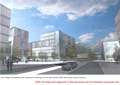
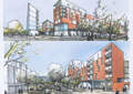
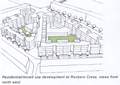
Roxboro Cross
The Roxboro Cross
neighbourhood is located at the centre of the Plan to form a
dynamic, vibrant place which is a major part of the urban identity
of the district as a whole. It will form the heart of the new
Southill, with its major civic hub or town centre. This centre,
illustrated adjacently (click
here to view), will be the location for the main public
buildings, retail facilities, and employment uses of the new
district, based around the intersection of the new urban cross
roads, and the diagonal route. It forms a major gateway location,
both to the Southside Regeneration Area, and to the City as
a whole.
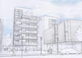
Four mixed use, high
density blocks surround the new crossroads To the north-east,
a site will be reserved for a new or extended Garda Station.
To the north-west, a mixed use residential development, accommodating
the new local health centre and other retail or commercial uses
on the ground floor, defines the diagonal walking and cycling
route, and surrounds a small, south facing public space associated
with cafes and local services.
Diagonally opposite,
forming the south-east corner, is another mixed use development,
accommodating mainly retail uses and supermarket at ground level,
and a series of open spaces.
The Plan's indicative
designs for these two blocks propose landmark developments celebrating
the gateway and defining the cross roads. The indicative design
for the block to the south propose a six storey landmark office
building defining the edge to Childer's Boulevard.
The elevation to
Roxborough Road is defined by a retail and residential building,
which increases in height to the cross roads. The massing and
arrangement of the buildings seeks to reflect the diversity
of the new district, with an appropriate form facing the relevant
streets and public spaces. Materials with local association
to Limerick, and in particular to the historic core, are reflected
in the new development, with red brick and limestone details
and paving suggested for the finishes.
The fourth corner
will be formed by a redevelopment of the eastern portion of
the LEDP site to accommodate a new proposed Adult and Further
Education, municipal offices, a local library, and a theatre.
To view
the complete 'Master' Plans,"Limerick Regeneration:
A Vision For Moyross, Southill & Ballinacurra Weston and
St. Mary's Park" click
here